
One article a day, three levels your way.
Free graded English reading: every article comes in Easy, Medium and Hard, with listen-along audio. Vocabulary and quizzes are free with an account. Sign up free →
Longer sentences, more descriptive words (about B1)
The Forested Floodplains of Congaree National Park
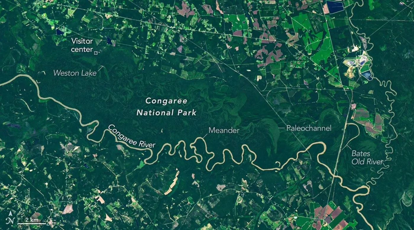
Few of the 63 national parks in the United States are shaped so strongly by one river floodplain. Congaree National Park in South Carolina is an exception. About 80 percent of its land lies inside the floodplain of the Congaree River. A floodplain is the low, flat land beside a river that can fill with water. The park still contains a large area of old-growth forest on this wet, low land. In that forest, trees have grown for a long time without being cut.
A satellite image shows the brown river winding through dark green forest. Green curves mark older channels and low ridges formed as the river slowly changed its path. Because these old channels sit at slightly different heights, they do not flood at the same time. That variation supports different groups of plants, which appear as different greens in the image.
The ground is soft and almost flat, so the river forms wide bends. Water moves faster along the outside of each bend and wears away that bank. Inside the bend, slower water drops sand and builds new land. Over time, a bend can separate from the river. It then becomes a U-shaped lake called an oxbow lake. Weston Lake is seen as one of the more lasting oxbow lakes in the park because it is fairly deep. Bates Old River runs about 4 miles and is among the longest oxbow lakes in South Carolina. After they are cut off, these lakes may fill with soil and become wet, low land. The wettest of these places often support trees such as cypress and tupelo, which can live in standing water.
Timber companies worked along the Congaree River in the 1880s. Frequent high water, wet roads, and large numbers of mosquitoes made the work difficult. As a result, much of the floodplain forest was never cut on the scale seen elsewhere in the Southeast. In the 1950s, people who wanted to protect the land took notice. This kind of old forest had become rare in the region. Congress made the site a national monument in 1976 and a national park in 2003. Inside the park, the river regularly leaves its channel because the land is nearly flat. These floods happen several times each year. They occur most often in winter and early spring, and also after hurricanes or heavy storms. Each flood lays down rich soil that feeds the forest and helps explain its many very large trees. For many years the park has been home to trees listed as national or state champions for their kind. The lists change when a tree is injured, dies, or when a larger tree is found somewhere else. These champion trees have included possumhaw, water hickory, laurel oak, swamp tupelo, sweetgum, and loblolly pine.
Adapted from NASA Earth Observatory.
Select Vocabulary or Quiz to practice.
Vocabulary
10 key words — tap a word for its meaning and an example
Quiz
10 questions