
One article a day, three levels your way.
Free graded English reading: every article comes in Easy, Medium and Hard, with listen-along audio. Vocabulary and quizzes are free with an account. Sign up free →
Longer sentences, more descriptive words (about B1)
El Niño Then and Now
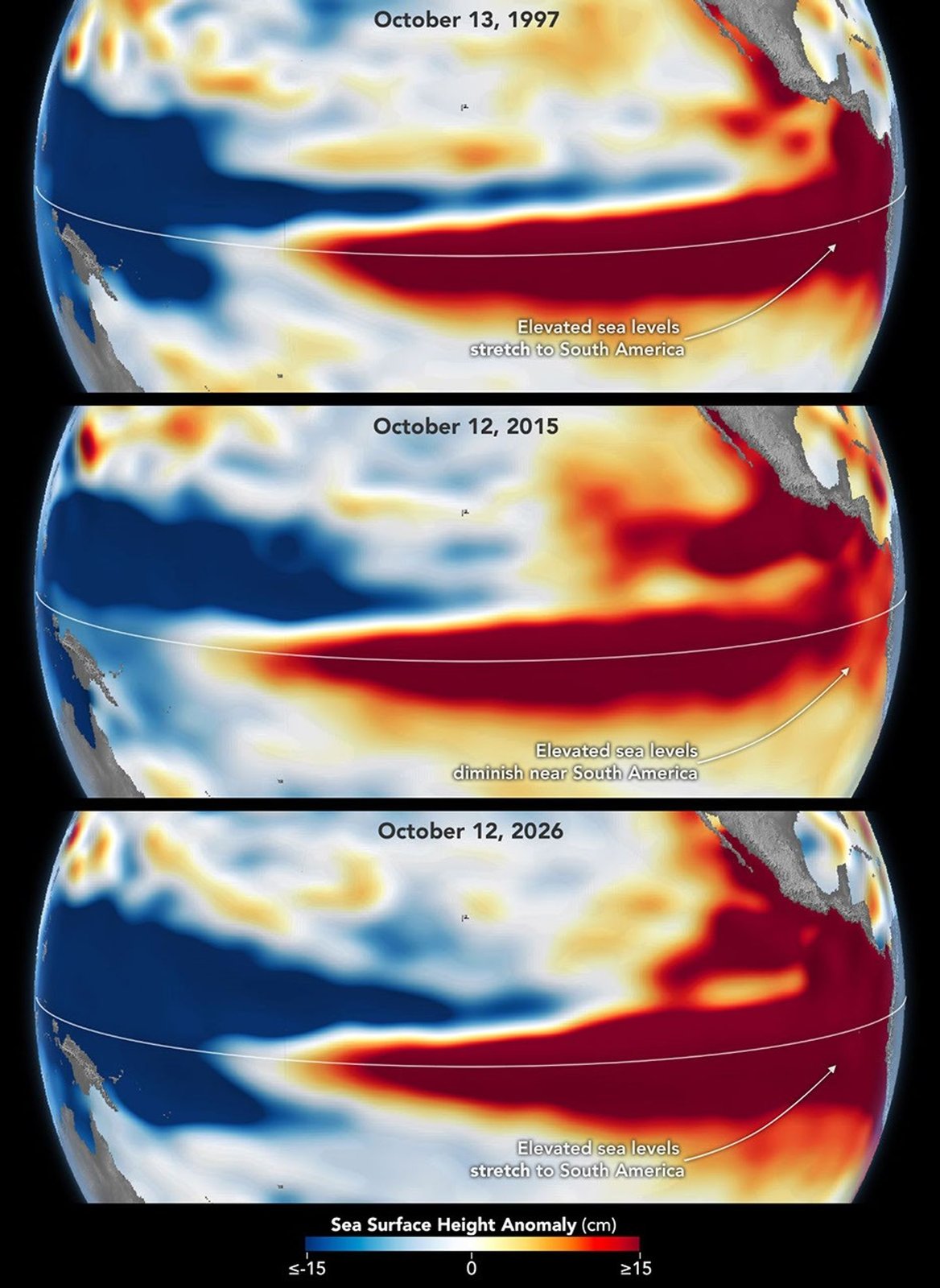
El Niño is a natural climate pattern that occurs every two to seven years. It brings warmer-than-average water to parts of the equatorial Pacific. The strong events of 1997-98 and 2015-16 changed weather patterns around the world. They caused fires in Indonesia and the Amazon, crop failures from drought in southern Africa, and heavy rain with flooding in Southern California. The current El Niño is as powerful as those past events.
Every El Niño grows through a feedback loop between the ocean and the atmosphere. Trade winds normally keep warm water piled up in the western Pacific. When the winds weaken, the warm water moves eastward and weakens the winds even more. This allows more warm water to move east, and the process strengthens in the central and eastern Pacific. However, each El Niño is different depending on where the warm water builds and how the atmosphere responds. Josh Willis, a scientist at NASA’s Jet Propulsion Laboratory, said that no two El Niños are exactly the same.
Satellites measure sea surface height to track El Niño. Warm water expands, so higher sea levels in the central and eastern Pacific show where heat is building. Maps from October 1997 and October 2026 show similar patterns of high sea levels reaching South America. Willis said the long satellite record lets scientists compare the current event to 1997, and this one may become even larger. The 2026 El Niño developed more suddenly than the 1997-98 event, but the two look similar now. As a result, the impacts could be similar, such as heavy rain in California and the southern United States.
The 2015-16 El Niño was also strong but different. In 2015, the highest warm water stayed farther from South America. Rainfall that winter focused more on Central America and the southeastern United States, with major flooding in Mexico. NOAA said in October 2026 that there is an 83 percent chance of a strong El Niño continuing into early 2027. However, the exact effects in winter 2026-27 remain uncertain because the atmosphere is chaotic. Willis noted that even if this El Niño looks like 1997, the impacts may not be exactly the same.
Why do scientists say the impacts of the current El Niño may not be exactly the same as those in 1997, even though the patterns look similar?
Adapted from NASA Earth.
Select Vocabulary or Quiz to practice.
Vocabulary
12 key words — tap a word for its meaning and an example
Quiz
7 questions